
Last update images today Conquering Peaks: Height Maps Explained
Conquering Peaks: Height Maps Explained
Introduction: Unveiling the Majesty of Mountain Range Height Maps
Have you ever wondered how cartographers and game developers create realistic mountain landscapes? The secret lies in mountain range height maps - visual representations of terrain elevation, transformed into a format computers can understand and utilize. This week, we're diving deep into the fascinating world of mountain range height maps, exploring their creation, applications, and the secrets they hold about our planet's most impressive geological features. This article is for anyone from geography enthusiasts and aspiring game developers to educators looking for a unique way to visualize the world.
Target Audience: Geography enthusiasts, game developers, educators, students, anyone interested in cartography and 3D modeling.
What is a Mountain Range Height Map?
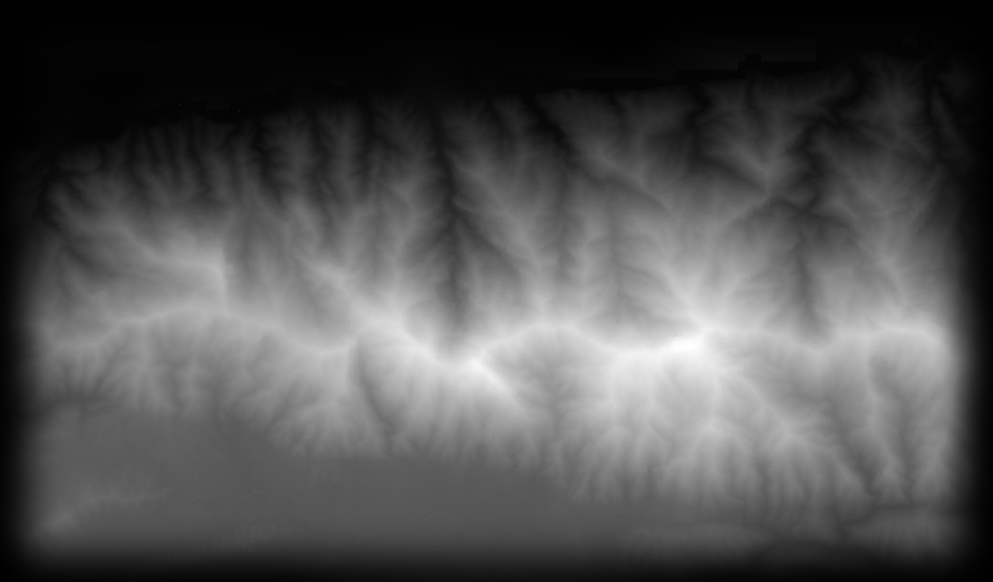
A mountain range height map is essentially a grayscale image where the intensity of each pixel corresponds to the elevation of a particular point on a terrain. Lighter pixels represent higher elevations (mountain peaks), while darker pixels indicate lower elevations (valleys and plains). This data can then be interpreted by computer software to create 3D models of the terrain. They are crucial for accurately representing the world's most dramatic landforms.
Mountain Range Height Map: How are they Made?
Several methods are used to create mountain range height maps:
- Satellite Imagery: Satellites equipped with radar or laser altimeters (like LiDAR) can accurately measure the distance to the Earth's surface. This data is then converted into a height map. This is the most common and reliable method for large areas.
- Aerial Photography: Stereoscopic aerial photographs are taken from different angles. By analyzing the parallax (the apparent shift in position of an object when viewed from different angles), elevation data can be derived.
- Digital Elevation Models (DEMs): Pre-existing DEMs, often created by government agencies or research institutions, are readily available for many regions. These can be downloaded and used directly or further processed. The USGS, for example, provides DEM data for the United States.
- Manual Creation: In some cases, particularly for fictional terrains in games or movies, height maps can be created manually using image editing software. This allows for artistic control over the terrain's features.
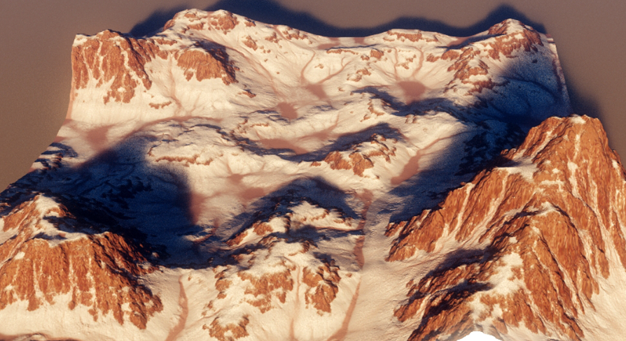
Caption: A mountain range height map visualized in grayscale, where lighter areas represent higher elevations. Alt Text: Grayscale image showing a mountain range height map.
Mountain Range Height Map: Applications in Various Fields
Height maps have widespread applications across various industries:
- Game Development: Crucial for creating realistic and immersive environments in video games. The "open-world" genre heavily relies on height map data.
- Film and Animation: Used to generate realistic landscapes for movie sets and animated scenes. They allow visual effects artists to seamlessly integrate CGI with real-world footage.
- Cartography and GIS: Height maps are fundamental for creating topographic maps, analyzing terrain features, and conducting geographical studies. Geographic Information Systems (GIS) heavily rely on these datasets.
- Urban Planning: Used to model terrain for infrastructure development, such as road construction and flood risk assessment.
- Scientific Research: Scientists use height maps to study erosion patterns, glacier movement, and other geological processes.
- Flight Simulation: Height maps are a key ingredient in creating the realistic terrains used in flight simulator software.
Mountain Range Height Map: Choosing the Right Height Map
Selecting the appropriate mountain range height map depends on your specific needs. Key factors to consider include:
- Resolution: Higher resolution height maps provide more detail but require more processing power. Determine the level of detail required for your application.
- Accuracy: The accuracy of the height map is crucial, especially for scientific and engineering applications. Check the data source and methodology used to create the map.
- Coverage Area: Ensure that the height map covers the area of interest.
- File Format: Common file formats include RAW, TIFF, and PNG. Choose a format compatible with your software.
- Source: Consider reputable sources of height map data. Government agencies (like the USGS) and specialized data providers are generally reliable.
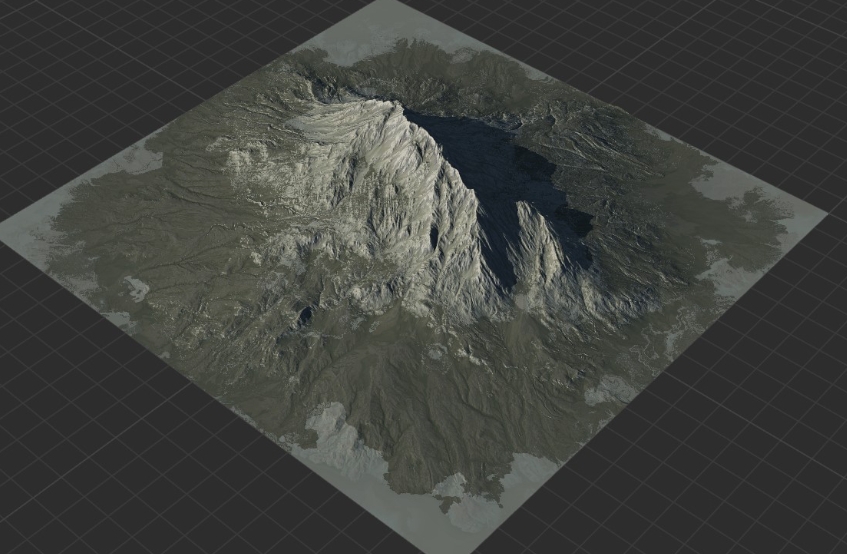
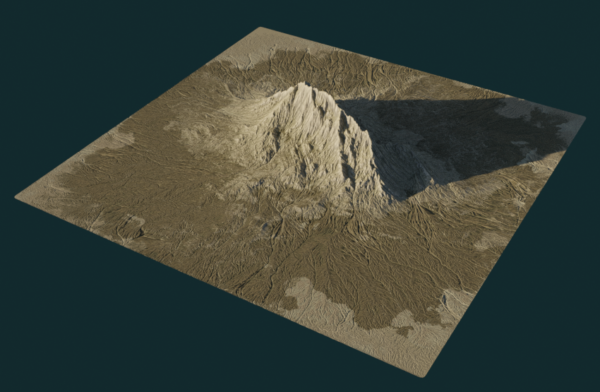
Caption: 3D rendered mountain range created from a height map data. Alt Text: 3D mountain range visualization from height map data.
Mountain Range Height Map: Tips for Working with Height Maps
- Software: Familiarize yourself with software designed for height map manipulation, such as QGIS, Blender, World Machine, or Terragen.
- Normalization: Height maps are often normalized to a range of 0 to 1. Understand how your software handles this normalization.
- Filtering: Apply filters (e.g., Gaussian blur) to smooth out the terrain and reduce artifacts.
- Scaling: Adjust the vertical scale to exaggerate or flatten the terrain features.
- Texturing: Apply textures to the 3D model based on the height map data to create realistic surface details.
Mountain Range Height Map: The Future of Terrain Modeling
The future of mountain range height maps and terrain modeling is bright, driven by advancements in:
- Higher Resolution Data: Expect even higher resolution data from improved satellite and aerial imaging technologies.
- AI and Machine Learning: AI algorithms are being used to automatically generate height maps from satellite imagery and to improve the accuracy of existing data.
- Real-time Terrain Generation: Real-time terrain generation techniques are becoming more sophisticated, allowing for dynamic and interactive landscapes in games and simulations.
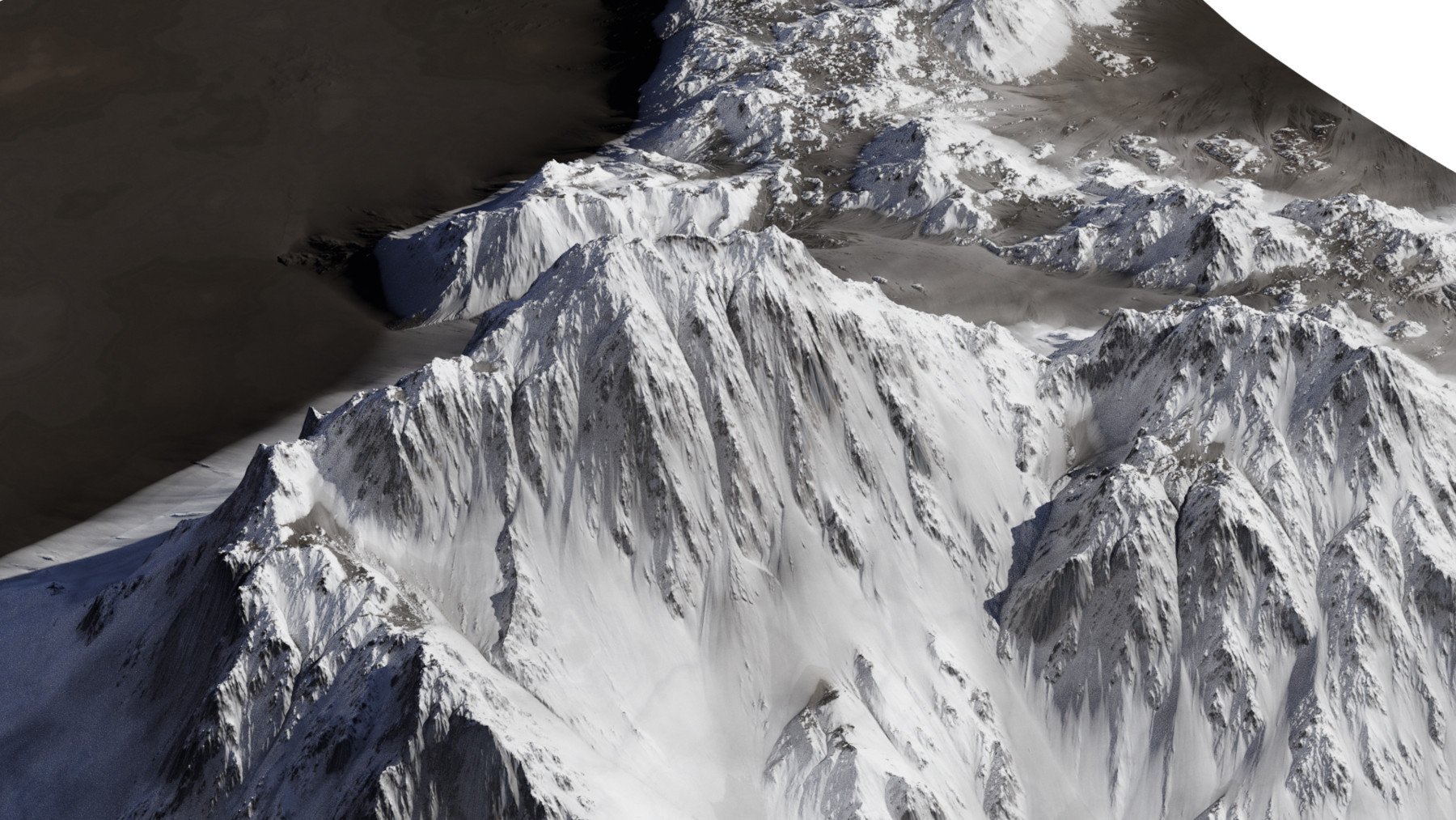
Caption: An example of a high-resolution mountain range height map. Alt Text: Detailed high-resolution height map of a mountain range.
Mountain Range Height Map: Question and Answers
- Q: Where can I find free mountain range height maps?
- A: The USGS Earth Explorer is a good starting point. You can also find free datasets on websites like Terrain.Party (for smaller areas) and some open-source GIS data repositories.
- Q: What software is best for editing height maps?
- A: Popular choices include QGIS (free and open-source), Blender (free and open-source), World Machine (commercial), and Terragen (commercial). The best choice depends on your budget and specific needs.
- Q: How do I convert a height map into a 3D model?
- A: Most 3D modeling software (like Blender, Maya, or 3ds Max) can import height maps and use them to generate a 3D mesh. Consult the software's documentation for specific instructions.
- Q: What is LiDAR?
- A: LiDAR (Light Detection and Ranging) is a remote sensing technology that uses laser light to measure distances to the Earth's surface. It is a highly accurate method for creating height maps.
- Q: What does "resolution" mean in the context of height maps?
- A: Resolution refers to the number of data points (pixels) per unit area. A higher resolution height map will have more detail and will be able to represent smaller features. For example, a 1024x1024 height map will have more detail than a 512x512 height map for the same geographic area.
Conclusion: Your Journey into Mountain Range Height Maps Begins
Mountain range height maps are a powerful tool for visualizing and understanding the Earth's terrain. Whether you are creating a realistic game world, analyzing geographical data, or simply exploring the beauty of mountains, height maps provide a unique and valuable perspective. With the resources and information provided here, you can begin your journey into the fascinating world of terrain modeling.
Summary Question and Answer: What are mountain range height maps, how are they created, and what are their common applications? They are grayscale images representing terrain elevation, created using satellite imagery, aerial photography, or DEMs, and are used in game development, film, cartography, and scientific research.
Keywords: mountain range height map, height map, DEM, digital elevation model, terrain, 3D modeling, game development, cartography, GIS, LiDAR, terrain generation, elevation data.


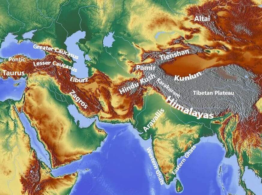


Landscape Height Maps Motion Forge Pictures Unreal Engine Compressed 768x432 The Top 5 Tallest Mountains In The World Are All Located In Mountain The Top 5 Tallest Mountains In The World Are All Located In V0 P1cy9zn4wkca1 Landscape Height Maps Motion Forge Pictures Featured Mountain Height Map Preview V2 600x392 Landscape Height Maps Motion Forge Pictures Featured Image Grand Mountains By The Sea 1536x1032 Mountain Range 8k Height Map Motion Forge Pictures Dark Alien Landscape 700x457 ArtStation 10 Realistic 8K Alpine Snowy Mountains Displacement Height File Major Mountain Ranges Of The World Highest Mountain Peaks PMF IAS Mountains Ranges In Asia
Heightmap Improvements Will We See Bigger Mountains Or Just Better XriCX Topographic Height Map With Mountains Premium AI Generated Image Topographic Height Map With Mountains 1014672 22842 Topographic Map Of Us Mountain Ranges Boriss Anderson Igp7056s4a361 Topographic Height Map With Mountains Premium AI Generated Image Topographic Height Map With Mountains 1014672 22821 Height Maps AIEasyPic Go Service.aieasypic.comLandscape Height Maps Motion Forge Pictures 8k Mountain Height Map Preview 800x522 Printing Mountains Energeia Medium 1*pxSk8L4untWMRhRLBfL6KQ
ArtStation 10 Realistic 8K Alpine Snowy Mountains Displacement Height File Black And White Height Map Of Mountains On Craiyon 549583a0e0ec4a059bb0ba5ee4fcdd38.webpInfinite Mountain Height Map Questions Answers Unity Discussions 923865a1dc2e6807b8ea7a21d6ff07442b64e61d Grand Mountain Height Map Free Download Motion Forge Pictures Featured Mountain Height Map V2 800x523 ArtStation 10 Realistic 8K Alpine Snowy Mountains Displacement Height File Map Of The Proportion Of All E IMAGE EurekAlert Science News Releases Public60 Pcs Red Sandy Rock Mountain Range Height Maps With Colormap 60PcsRedSandyRockMountainRangeHeightMapsWithColormap Featured 894x488 6d28db099907d7212dee3dfdecbd3dc5 ArtStation 201 Mountain Heightmaps UE5 Resources File
Major Mountain Ranges Of The World Highest Peaks Map Major Mountain Ranges Of The World Map Topographic Height Map With Mountains Premium AI Generated Image Topographic Height Map With Mountains 1014672 22618 Infinite Mountain Height Map Questions Answers Unity Discussions Bbf2f118248c567772bfdc2811af6a6fc9444c51 Mountain Ranges Map World Labeled Rocky Mountain Range Map Mountain Ranges Map Mountain Range 8k Height Map Motion Forge Pictures Featured Image Swamp Preview 1536x935 Major Mountain Ranges Of The World Highest Mountain Peaks PMF IAS Highest Mountains On Earth Landscape Height Maps Motion Forge Pictures Featured Mountain Height Map 8k Mountain Range Landscape Height Map Free Download Motion Forge Free Download Image 1
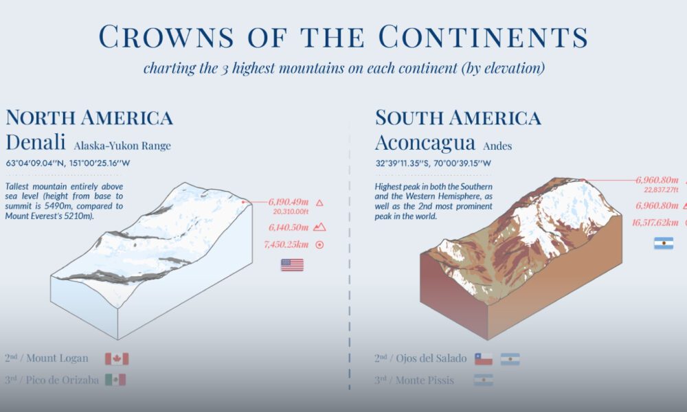
Mapping The World S Highest Mountains By Continent CP Crowns Of The Continents SHAREABLE Higher Res 1000x600 Grand Mountain Height Map Motion Forge Pictures Height Map Compressed 1200x675 Mountain Range 8k Height Map Motion Forge Pictures FeaturedImage 800x522